Purpose
Through Forward Pinellas’ Investment Corridor framework, a set of roadway corridors within Pinellas County have been prioritized for strategic improvements to enhance access to jobs, housing and multimodal transportation options. The East Bay Drive/Roosevelt Boulevard is identified as one of these priority corridors, reflecting its importance in connecting communities, businesses, and key local and regional destinations such as HCA Florida Largo Hospital and St. Pete-Clearwater International Airport.
This study was coordinated with local and regional partners, including the Florida Department of Transportation (FDOT), Pinellas Suncoast Transit Authority (PSTA), the City of Largo, and Pinellas County. The goal is to develop a multimodal transportation and corridor improvement strategy that supports safer, more efficient travel by all modes of transportation, while also encouraging access to land use and economic development opportunities along the corridor. The study involves an extensive public outreach and stakeholder engagement process that ensures the recommendations reflect the community’s priorities and needs.
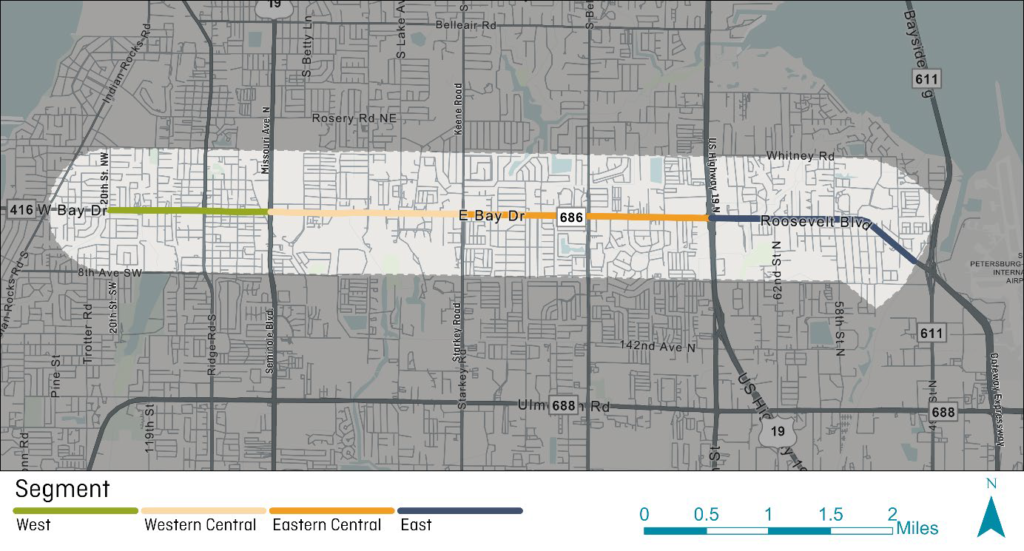
Study Area
The study corridor extends from 20th Street to Lightwave Drive, near St. Pete-Clearwater International Airport. The corridor study area primarily consists of residential and commercial uses, including major destinations such as HCA Florida Largo Hospital and St. Pete-Clearwater International Airport. The study area also encompasses downtown Largo along West Bay Drive. It also includes major employers such as TD SYNNEX located at Bay Vista Office Park on Roosevelt Boulevard. The corridor is served by PSTA’s Route 52, which increased its service frequency in October 2025 from every 30 minutes to every 15 minutes. The East Bay Drive/Roosevelt Boulevard Corridor serves a mix of local and regional travel, making improvements for all road users vital to enhance safety, accessibility and connectivity.
Project Phases
Phase 1- Corridor Context
Led primarily by FDOT, the study team documented existing conditions along East Bay Drive/Roosevelt Boulevard within the study segment, including the existing transportation network, existing and future land use plans and patterns, and conducted a safety analysis. This phase laid the foundation for the study by identifying key issues, trends and opportunities for improvement.
Phase 2 – Corridor Mobility Evaluation and Public/Stakeholder Outreach (Ongoing)
Building on Phase 1, this phase analyzed current and projected travel patterns along the corridor for all road users: drivers, transit riders, bicyclists and pedestrians. The team evaluated the key areas of activity along the corridor based on existing and future land use regulations. This phase also included extensive public and stakeholder outreach, consisting of an online survey, tabling at community events, and presentations to community stakeholders, including major employers along the corridor. The result of this phase was a comprehensive understanding of how people move along the corridor today and how travel may change in the future.
Phase 3 – Corridor Action Plan
In the final phase, the study team will develop short-, mid-, and long-term strategies to improve safety, accessibility, and multimodal travel along the corridor. The action plan will outline the roles of agencies and entities responsible for implementation of improvement projects. The phase will also include community and stakeholder review, ensuring the recommendations reflect local needs and support economic development along this corridor.
Public and Stakeholder Outreach
During Phase 2 of the study, a variety of in-person and online engagement activities were used to gather input from the community, local businesses, and other key stakeholders along the East Bay Drive/Roosevelt Boulevard corridor. The study team hosted presentations and work sessions with City of Largo entities including their Commission, Planning Board and local committees. Tabling events were held at community events as well as at Largo High School to conduct targeted outreach with students who frequently use the corridor. Additionally, tabling was conducted at key employment locations such as Bay Vista Office Park. These outreach efforts provided opportunities to discuss key safety issues, mobility needs and corridor improvement opportunities from a wide-ranging group of community members.

Outcomes
The outcome of this study will include the development of a Corridor Action Plan, outlining short-, mid-, and long-term strategies and recommendations. The plan will also identify potential funding sources and the agencies or entities responsible for implementation. The Corridor Action Plan will be developed using a data-driven approach, incorporating the existing conditions analysis, the multimodal evaluation, and the long -term future land use vision established by the City of Largo.