By Emma Wennick, Program Planner, Forward Pinellas
When Forward Pinellas adopted the Multimodal Accessibility Index (MAX Index) into the Countywide Plan in 2023, it marked a shift in how transportation impacts are evaluated during Countywide Plan Map amendment reviews. The MAX Index allows Forward Pinellas and local governments to test how future transportation investments could improve accessibility and support long-term planning goals and is a required component of amendment applications to the Countywide Plan Map.
This article serves as a refresher and focuses on how the MAX Index is implemented today, how it applies to Countywide Plan Map amendments, and how planners and applicants should use it during project review.
If you are unfamiliar with the MAX Index, we encourage you to first read: Introducing the MAX Index: A New Way Forward Beyond Level of Service.
What the MAX Index is and How it Works
Historically, transportation impacts in Pinellas County were evaluated primarily using Level of Service (LOS), a roadway performance measure focused on vehicle congestion. While LOS remains part of the transportation framework, it does not account for walking, bicycling, transit access, or other multimodal features that shape mobility in a largely built-out county.
To provide a more comprehensive view of accessibility, Forward Pinellas adopted the Multimodal Accessibility Index. Rather than measuring only roadway congestion, the MAX Index evaluates how well an area supports multiple transportation options.
The MAX Index is a GIS-based tool that assigns scores to quarter-mile grid cells across Pinellas County, reflecting a reasonable walking distance. Each grid cell receives points based on the presence of multimodal transportation features within or near that cell. These features include:
- Walkability
- Transit access and service frequency
- Bicycle infrastructure (such as separated bike lanes)
- Trail access
- Micromobility options (bike share, scooters, etc.)
- Transportation Improvement Program (TIP) funded projects
- Select roadway performance measures (including LOS and volume-to-capacity ratios)
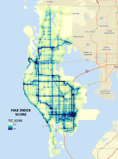
Features may contribute points multiple times within a grid cell, and nearby infrastructure can also be counted based on proximity. The cumulative total results in a single numeric score representing overall multimodal accessibility.
Under Table 6-5 of the Countywide Rules, each feature is assigned a specific point value. For example, separated bike lanes and Bus Rapid Transit receive three points, walkability scores at or above the countywide average receive two points, and transit access, micromobility access, and TIP-funded improvements contribute one point each. Roadway performance measures such as LOS D or better and favorable volume-to-capacity ratios also contribute to the total score.
Together, these factors create a balanced accessibility metric that supplements traditional roadway analysis and better reflects how people travel in Pinellas County today.
The Countywide Average MAX Index Score
Each year, Forward Pinellas updates the MAX Index using the most current data available.
For 2026, the countywide average MAX Index score is 8.1, an increase from 7.1 in 2025. The increase is primarily attributable to:
- Expanded transit coverage and improved service frequency
- Growth in micromobility infrastructure
- Incremental gains across multiple multimodal features
- Refinements to GIS datasets and feature counts
The countywide average serves as a critical benchmark in applying the Countywide Rules and evaluating Countywide Plan Map amendments.
How Planners and Applicants Use the MAX Index
The MAX Index is not just informational. It is a required component of Countywide Plan Map amendment applications.
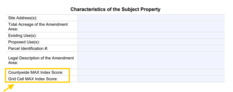
Applicants must identify two related MAX Index values in their submittal:
- Countywide MAX Index Score
- Grid Cell MAX Index Score: the score assigned to the quarter-mile grid cell in which the amendment parcel is located. This score is used to determine whether the amendment area meets or falls below the countywide average score of 8.1.
If a proposed amendment area intersects multiple MAX Index grid cells, the scores of all intersected grid cells must be averaged. The average score is not rounded and is used for Countywide review purposes.
Accurately identifying these scores early in the process helps applicants understand how the amendment will be evaluated and which Countywide Rules may apply.
See below a screenshot of the Countywide Plan Map Amendment Application showing required MAX Index fields.
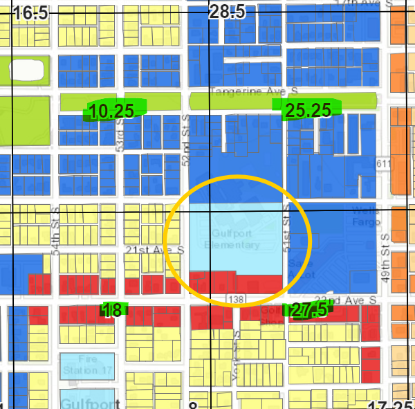
Where to Find the Grid Cell MAX Index Score
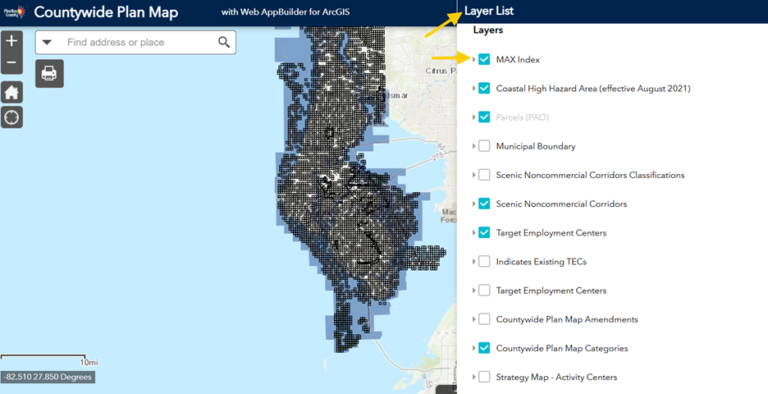
The Grid Cell MAX Index Score can be found using the Countywide Plan Map.
To locate the score:
- Open the Countywide Plan Map
- Navigate to the Layers section
- Turn on the MAX Index grid layer
- Locate the parcel associated with the proposed amendment
- Identify the intersecting quarter-mile grid cell(s) and record the score(s)
This step is essential, as the grid cell score determines whether an amendment area is considered underperforming under the Countywide Rules.
See screenshot below of the Countywide Plan Map with the MAX Index layer turned on in the Layers panel.
What Happens if a Grid Cell is Underperforming
Under Section 6.5.5 of the Countywide Rules, a quarter-mile grid cell that does not meet or exceed the countywide average MAX Index score is classified as underperforming.
If a proposed Countywide Plan Map amendment would increase density or intensity within an underperforming grid cell, the amendment must be evaluated using the balancing criteria in Section 6.5.5.2 of the Countywide Rules.
These criteria allow the Pinellas Planning Council (PPC) and the Countywide Planning Authority (CPA) to consider factors such as:
- Whether the amendment is located within a Community Redevelopment Area (CRA)
- Whether the project includes planned multimodal infrastructure tied to a binding local government action
- Whether the amendment involves AC, MMC, or PRD categories over a specified acreage
- Whether the amendment area intersects multiple grid cells whose average score meets or exceeds the countywide average
- Consistency with adopted local multimodal plans or land development regulations
Importantly, the MAX Index is intended to support informed decision-making, not to prevent redevelopment. The balancing criteria recognize that transportation improvements and redevelopment often occur together and over time.
Why the MAX Index is a Useful Tool
By supplementing traditional LOS measures with multimodal accessibility data, the MAX Index:
- Provides a more comprehensive picture of mobility
- Reflects how people actually travel in a developed county
- Supports redevelopment and reinvestment
- Encourages multimodal infrastructure improvements
- Aligns transportation evaluation with adopted countywide policies
Ultimately, the MAX Index allows Forward Pinellas and local governments to test how future transportation investments could improve accessibility and support long-term planning goals.
If you have questions/comments about the MAX Index or the Countywide Plan, please contact Emma Wennick, ewennick@forwardpinellas.org, 727-464-5679.