One of the things I enjoy most is finding a place that I can claim as my own. There’s an old Jimmy Buffett tune, “I Have Found me a Home,” which captures the comfortable ease of becoming part of an accessible, inviting community like Jimmy found in Key West and I’ve found in Dunedin, Winter Park and many other places where I’ve worked or visited. The song features accessibility prominently:
My old red bike gets me around. To the bars and the beaches of my town.
Each of us defines place differently. For me, it’s having easy access to places I enjoy. That might be a nearby trail or botanical garden, an historic cemetery, or an urban mixed use district with a fresh produce market and a distinctive taproom. What defines a sense of place for you?
Great Places and Walkability
The American Planning Association just announced its 2015 Great Places in America honorees. Each of the 15 selected streets, neighborhoods and public spaces is a distinctive, transformative place reflecting the values and special care taken in each community to plan, create and sustain them. The APA’s Great Places program is designed to celebrate the planning achievements that foster a sense of identity, belonging and create communities of lasting value.
How we access places is changing rapidly, with bike share, ride sharing businesses and the emergence of autonomous vehicles; yet walking will always be our primary means of experiencing place. Walking allows you to take in the full sensory richness of a place’s geography, its sights, sounds and smells. It also improves your health, with a growing body of data and research findings suggesting that those who live in walkable neighborhoods and regularly commute by non-auto travel choices are healthier, live longer, and are more productive in their jobs.
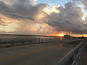
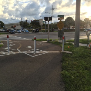
A useful and commonly accepted measure of walkability is whether there is a grocery store within about a five minute walk. My rental home on the Dunedin Causeway is rich in destination accessibility. I have a seven minute walk to the Publix grocery store, and myriad of other opportunities – recreation, retail, dining, and transit service – are nearby. I recently cataloged my trip to the store for some basic supplies after being out of town for nearly a week. The walk is easy, and supported by good infrastructure, signage and markings visibly and safely connecting walkers and people on bikes across the intersection of US Alternate 19 and Curlew Road, a busy beach access route to the Dunedin Causeway and Honeymoon Island State Park.
The Publix store has a direct sidewalk connection from the Pinellas Trail, a countywide shared use path network connecting the coastal communities in Pinellas along a former railroad line. The sidewalk from the Trail continues through the retail center’s parking lot, offering a well-marked pedestrian access to the grocery’s main entrance through what is typically a pedestrian danger zone. Most parking lots have little to no protection for those on foot, but the Dunedin Causeway Publix offers an exemplary case study within a multimodal village activity center for what works well by offering a safe and direct pedestrian connection to the front door.
Tools You Can Use
The relationship of place, livability and accessibility is influencing the development of new tools to enable evaluation of the quality of communities. Walk Score has become a user-friendly tool helping people find homes and apartments and for professionals to assess real estate trends and perform data analytics on neighborhood quality. The AARP has developed its own tool, the Livability Index, allowing users to select and weight different criteria for what makes a community, neighborhood or place more livable. These and other tools represent a democratization of transportation and community planning, enabling the general public to make a more informed decision about their communities and how best to improve them. Check them out for the place you live and work, see how places compare, and explore what’s most important to your sense of place and community.
Over the next two years, the Pinellas Planning Council and Metropolitan Planning Organization will be placing emphasis on three geographic areas with the goal of making them more accessible places for people using various travel modes. Developing a vision for the US 19 corridor, improving connectivity and destination accessibility in the Gateway district, and enhancing beach access will each focus on addressing the needs of vulnerable road users. They will also look toward key land use and transportation strategies to reinforce the economic value each brings to Pinellas County, individual communities and the Tampa Bay region.


Welcome to Dunedin!