by Dana Santos, MPH/MA, and Amy Elmore
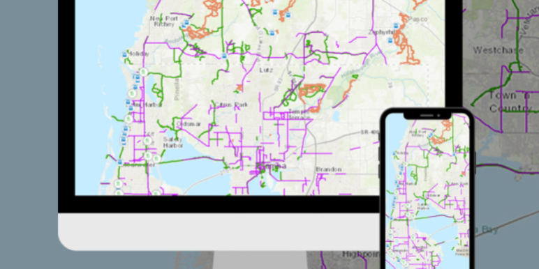
Do you enjoy biking from the city all the way to the coast? Discover trails that reach across county lines with the new Tri-County Trails Map!
Transportation leaders came together to develop an online, interactive map of the various multiuse trails and bicycle lanes located throughout Hillsborough, Pasco and Pinellas counties. The Sun Coast Transportation Planning Alliance (SCTPA) has launched the interactive, online Tri-County Trails Map, which highlights trails and bike lanes of the Tampa Bay region. For the first time, the Tri-County Trails Map brings together online information for trails throughout Hillsborough, Pasco, and Pinellas counties in one place! Trail users can access the interactive, Tri-County Trails Map from any device no matter where they are and easily search for nearby trails.
“The Tri-County Trails Map will serve as an extremely useful resource for all of our Tampa Bay residents and visitors. The SCTPA is proud to provide one source where anyone can find dedicated places to cycle for either recreation or to get around their communities,” says Hillsborough Commissioner and Tampa Bay Management Area Leadership Group Chair Kimberly Overman.
Interactive Tri-County Trails Map: CLICK HERE
How to Download the trails map: CLICK HERE

Formerly known as the West Central Florida Metropolitan Planning Organization Chairs Coordinating Committee, the SCTPA comes together to plan, prioritize and fund transportation improvements that will shape our shared future. As the region stands to see continued growth in population, economy and travel, the SCTPA provides sound, forward-thinking transit and transportation options to support this growth and a sustainable future for our region. The Tri-County Trails Map was originally envisioned by the Tri-County Bicycle Pedestrian Advisory Committee. More information about SCTPA can be found HERE.


